
As warmer temperatures move through the area, so do the storms that frequent the spring and summer months.
Adair and Guthrie County Emergency Management Coordinator Bob Kempf says that one of the more common types of storms that residents of Guthrie County may see is windstorms. He explains that the most common type of windstorm is straight lying winds. He explains that these winds occur more often than other windstorms, which is why they rack up so much damage. These are short bursts of fast winds that can precede other storms.
Kempf tells Raccoon Valley Radio how derechos differ from straight lying winds.
“So normally, when we have a squall line come through or a severe thunderstorm, we might have those high winds for a minute or two, something like that. As the storm actually the front of the storm is passing through with a duration, you will get those winds that might last 15 minutes, 30, even 45 minutes, blowing almost at a hurricane or tornadic speed that actually lasts for a long duration of time.”
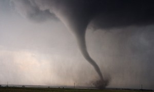
The third type of wind event that Kempf says the area sees commonly, is tornadoes. He adds that tornadoes occur when a warm air system and cooler system meet, which causes a tubular, horizontal wind. Eventually, this wind can move into a vertical position, and can cause some of the events that precede a tornado.
The most common, but not required event is a funnel cloud. Kempf explains that funnel clouds are a rotating wind that comes down from the cloud base, and is usually visible as a tendril of the cloud reaching down. He adds that what makes a funnel cloud turn into a tornado is contact with the ground, when it starts to pick up dirt and debris as it moves.